


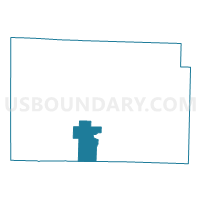
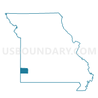
WEST JACKSON Voting District, Jasper County, Missouri
About
Outline

Summary
| Unique Area Identifier | 608779 |
| Name | WEST JACKSON Voting District |
| County | Jasper County |
| State | Missouri |
| Area (square miles) | 22.98 |
| Land Area (square miles) | 22.98 |
| Water Area (square miles) | 0.00 |
| % of Land Area | 100.00 |
| % of Water Area | 0.00 |
| Latitude of the Internal Point | 37.10498880 |
| Longtitude of the Internal Point | -94.37868560 |
Maps

Graphs
Select a template below for downloading or customizing gragh for WEST JACKSON Voting District, Jasper County, Missouri


Neighbors
Neighoring Voting District (by Name) Neighboring Voting District on the Map
- CARTERVILLE - ALL WARDS (1-4), Jasper County, MO
- Diamond Voting District, Newton County, MO
- DUENWEG Voting District, Jasper County, MO
- EAST JACKSON Voting District, Jasper County, MO
- JOPLIN NO. 25 Voting District, Jasper County, MO
- LAKESIDE Voting District, Jasper County, MO
- MONITOR Voting District, Jasper County, MO
Top 10 Neighboring County Subdivision (by Population) Neighboring County Subdivision on the Map
- Joplin township, Jasper County, MO (42,173)
- Marion township, Jasper County, MO (15,137)
- Mineral township, Jasper County, MO (9,100)
- Jackson township, Jasper County, MO (4,954)
- Marion township, Newton County, MO (3,787)
Top 10 Neighboring Place (by Population) Neighboring Place on the Map
- Joplin city, MO (50,150)
- Carthage city, MO (14,378)
- Carterville city, MO (1,891)
- Duenweg city, MO (1,121)
Top 10 Neighboring Unified School District (by Population) Neighboring Unified School District on the Map
- Joplin R-VIII School District, MO (59,509)
- Carthage R-IX School District, MO (23,293)
- Webb City R-VII School District, MO (21,342)
- Diamond R-IV School District, MO (5,638)
Top 10 Neighboring State Legislative District Lower Chamber (by Population) Neighboring State Legislative District Lower Chamber on the Map
- State House District 127, MO (40,320)
- State House District 128, MO (38,369)
- State House District 131, MO (36,451)
Top 10 Neighboring State Legislative District Upper Chamber (by Population) Neighboring State Legislative District Upper Chamber on the Map
Top 10 Neighboring 111th Congressional District (by Population) Neighboring 111th Congressional District on the Map
Top 10 Neighboring Census Tract (by Population) Neighboring Census Tract on the Map
- Census Tract 115, Jasper County, MO (9,723)
- Census Tract 204, Newton County, MO (7,401)
- Census Tract 103, Jasper County, MO (6,746)
- Census Tract 118, Jasper County, MO (4,756)
- Census Tract 119, Jasper County, MO (3,991)